Out of the Air for Two Weeks, but Planning a South America Trip Again?

It has been a long time since I wasn’t in the air for more than two weeks. In fact, it may have been more than a decade since this happened. Wow. Wonder when the shivers of withdrawal will start? They have to be soon. I’m already starting to count down the time until I am back in the air in 7 days. I guess a vacation (working one) isn’t that bad though.

But it doesn’t mean I haven’t been thinking about flying. The trip has been a “working” on on which I have spent time updating “Plans of Action” for practical tests. A part of the job of every examiner is to keep their practical test plans changing and up-to-date so they don’t become too predictable or stale. So new plans, new questions, and I will be ready to put them to use on upcoming practical tests in September! Something to look forward to for upcoming applicants right!?

ParaguyRoute_Page_1 I have also begun and finished a few articles written in the time I have been out of the air will hopefully show up in a couple publications over the next few months.

ParaguyRoute_Page_2In the break, I have also have gotten word that the Cessna 337 ferry trip to South America may be back on. With a couple modifications.

The new destination is now Asuncion, Paraguay (previous was Buenos Aires, Argentina). Continue reading

Reflections and Tips from Recent Practical Tests

I would like to share a few reflections and tips from recent practical tests I have given. In most cases, the tests I have given are proof of fantastic candidates who are dedicated to learning and progressing as pilots, but there are also moments that just leave me wondering about some of the basic preparation things that an applicant could do to make their time with me so much easier. So here are a few things I would offer:

  • Yes you should bring an FAR/AIM with you (unless somehow you have memorized it all) and yes it should be a current one. Too many times applicants either don’t have a FAR/AIM with them or one that is current. I’m not certain which is worse to be honest. Not having one is bad, having an old one just shows an applicant doesn’t care to have current information.
  • It is a really good idea to have a copy (digital pdf on your ipad is fine) of the Practical Test Standards for the test your are taking (and yes it should be current also). This is the menu the examiner will use on the practical test. Know it and have one. You can find these at https://www.faa.gov/training_testing/testing/test_standards/#pilots

Continue reading

Ok, so the GPS Was Doing What it was “Supposed” to Do, Just Not What I “Would Want” it To Do

Well, the GPS was working properly after all on the flight from the previous post (Normally when a pilot had a depiction of 3.9 nautical DME miles from a Class D airport and hadn’t talked with the tower on a practical test, I would have failed them….but…). After some more digging, we found it was doing exactly what it was programmed to do. It just isn’t programmed to do quite what I might think I would like it to do in such a situation.

The GPS wasn’t actually telling us the distance to the station that we had put into the FMS, it wasn’t “distance to the desired waypoint” from the present position of the aircraft to that what was programmed into the FMS that was being shown, it was in fact “distance to current waypoint along a track.”  More precisely, it’s the remaining distance along the path assuming the aircraft were on the path. It doesn’t’ matter if you are on the actual track that was programmed, or parallel to it. On it, 5 miles to one side, or 1000 miles to one side, it is going to track the distance along the parallel track to the perpendicular point of the originally set FMS point.

Confused yet?

So was I. So we made the system do it again.

It’s not an error if it does the same thing each time do the same thing right?

Continue reading

Normally when a pilot had a depiction of 3.9 nautical DME miles from a Class D airport and hadn’t talked with the tower on a practical test, I would have failed them….but…

In this case, things weren’t exactly as they seemed, and a little more detail is required, and it brought up a very interesting question. What if your GPS data is not depicting correctly.

1
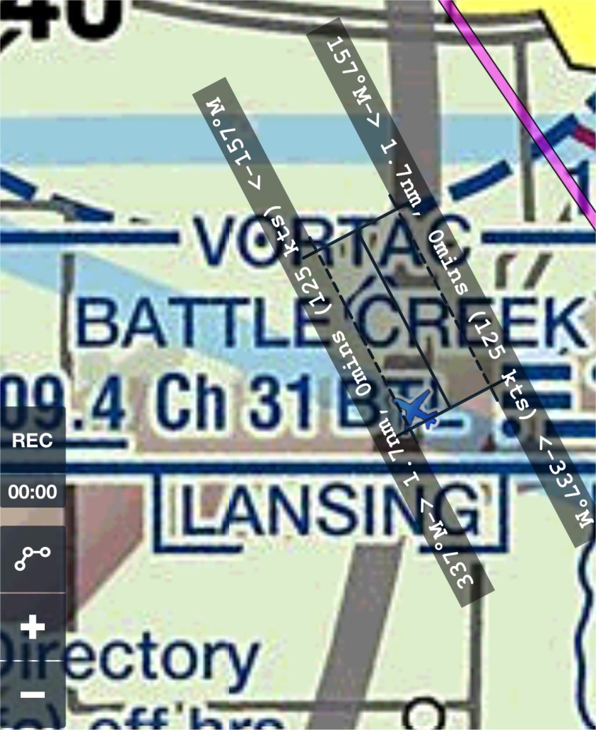
If you look at the first picture to the right, you can see a track (from a screen shot I took on my iPad with my charting software) that shows us approaching the KBTL Class D airspace ring. On a practical test, I will always stop an applicant from “getting us in trouble” and doing something such as breaking airspace. You can see our track on the screen shot was taking us very close to the KBTL airport.

In this case, we were navigating visually (not using the GPS to get to a point west of KBTL that is used as a common entry point to the airspace (a gate – high density training environment) and staying a little further north than we normally might to avoid some rain showers that were in the area. As we approached the area, I got a bit more sensitive to the proximity to the airspace as the applicant visually navigated using a chart and referenced the ground. I did the same, but also had my charting application running and shot this screen shot as we got closer to the airport. Continue reading