Flying a VOR approach? Asking yourself why you would do this instead of doing a GPS approach (assuming your aircraft is equipped with an IFR GPS system)?
Well, the answer might be because there isn’t a GPS approach to the runway or even the airport you are approaching, or, perhaps, some mean old examiner is just making you do a VOR approach on an instrument checkride. Yeah, we still do that when we can.
This doesn’t mean you can’t take advantage of your GPS system to fly the approach more accurately or in manner that integrates more fully with your avionics package and autopilot.
It is worth noting that there is an allowance in the FAA’s Airman’s Information Manual (AIM) that gives the pilot the ability to use the GPS system to “navigate” along a path when they are flying along the final approach segment of a VOR approach. Speficially, it notes:
AIM 1-2-3-c-5:
“Use of a suitable RNAV system as a means to navigate on the final approach segment of an instrument approach procedure based on a VOR, TACAN or NDB signal, is allowable. The underlying NAVAID must be operational and the NAVAID monitored for final segment course alignment”.
What this means practically is that a pilot may utilize their GPS RNAV system to actually fly along a VOR approach beyond the final approach fix as long as they can “monitor” the VOR (or TACAN or NDB) on a secondary radio and ensure that the GPS is navigating along the appropriate NAVAID course for the approach.
So, why might you want to do this you might be thinking right now.
Well, imagine that VOR approach that is to a VOR that isn’t based on the field, but that you will pass over along the approach path. Remember how that VOR performs when you fly over it and the “cone of confusion” that we all learned about? That period of time where we just fly on our track for a bit until the VOR needles center and become effective again? That works when we are hand flying, but it can make an autopilot do some funny things if the pilot doesn’t intercede in that period of time.
Let alone the fact that a VOR is typically just less accurate than a GPS based navigation profile will be anyway.
The reality is that a GPS that is IFR certified is typically going to report more accurately the aircraft’s position along a final approach segment, more quickly, and with less potential error than a VOR radial. Especially when we think of a VOR approach that might be to an airport that is miles or even tens of miles from the VOR being utilized.
Secondarily, the ability to couple a GPS to an approach capable autopilot increases the aircraft stability along the path and lessens the chances that a pilot will
Sure, it is still important for pilots to maintain their physical stick flying skills, and it is critical they monitor their autopilots and GPS systems to ensure they have been programmed correctly and are navigating as expected, but substituting the use of a navigation path that is GPS generated for one that is VOR dependent as long as the primary VOR course can still be monitored will typically result in a more stable approach. Especially when it is flown by an autopilot system.

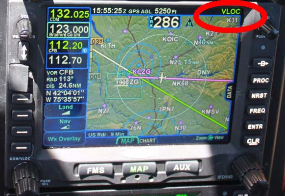
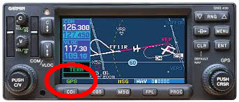
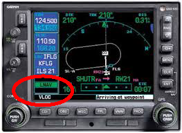
To do this, it might be as simple as ensuring that your navigation mode has been selected to “GPS” mode instead of “VLOC” in your Avidyne or Garmin system to name a couple of the most prevalent systems used in general aviation and training aircraft today.


Get to know how to select the CDI mode, how to have a secondary navigation system being monitored, and how to determine if you are in VLOC or GPS mode on your navigation system. If you are a little rusty on this or have never been taught it, grab an instructor who is familiar with your avionics system and go give it a try on some flying, or even a few approaches in some good VFR weather to get comfortable and proficient before you need to do it on an IFR flight.
Additionally, setting up your flight plan, having the FMS help, and/or loading the approach properly will offer more sequencing data from the GPS than a “raw data” flown approach may provide. Having DME data from initial to intermediate, final, or missed approach points enhances the pilot’s position awareness through the entire approach procedure.
Plan appropriately and make sure you are set up in the correct mode and you can make that next approach just a little more stable. Oh, and to add one more thing, most IFR GPS systems also have the missed approach procedures sequenced. It will make them easier to transition to if you need it in real life, or just as a part of your checkride.
Jason, very solid comments on flying the VOR course in GPS. Keep up the great work.
Ken
Very helpful. Thank you!
So on a IFR check ride, flying a VOR using my GPS, while monitoring the VOR is acceptable ?
Correct!
I guess I’m considered ‘old school’, having gotten my instrument rating in the mid 70s, way before GPS existed.
I live near WHITE SANDS MISSILE RANGE, who….frequently jams many frequencies, including GPS and ADS-B. It’s not unusual to see
GPS signals fall to zero on my GNS-430 and GTN-650. I fly right seat in a King Air E-90 where we’ve seen GPS go away at flight level altitudes, necessitating an immediate change to VOR navigation. Thus can be a challenge if you’re cleared direct to a destination and not on a published airway.
While I agree in concept with Mr. Blair’s article above, my concern is that way too much emphasis is placed on the GPS little magenta line for navigation and not enough training on how to revert to the older system when the need arises.
Consider losing GPS in the middle of the procedure turn on a VOR approach prior to the FAF. (obviously the VOR is not located on the airport). Since the FARS require monitoring the actual VOR signal with a second radio, is the pilot mentally prepared to transition to the VOR
system to continue the approach?
This is a very real scenario.