Calculating Descents from Higher Altitudes

One of the major benefits of flying higher, is that you get to descend for a longer distance, using less fuel, and typically at a faster speed across the ground. But taking advantage of these longer descents takes a little planning.

If we consider an aircraft that would descent at 200 knots from FL250 down to an approach altitude of 3000’ MSL, we have a long ways to descend and if we complete this at a comfortable 500’ per minute descent, it would take a 153 miles over 44 minutes to complete the descent. This descent is longer than many cross-country flights that pilots in smaller light general aviation aircraft fly!

To put this in perspective, I have include here a chart that show descent rates of 500’ per minute and 1000’ per minute from various flight altitudes to demonstrate the mileage and time it would take to complete these descents. Continue reading

Generic LSA Aircraft Codes for IACRA When Aircraft Not Found

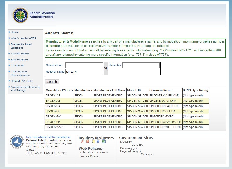
In a recent practical test, I ran into the IACRA challenge that the aircraft to be used for the test, in this case, a Flight Design CT, was not available in the list of aircraft for the applicant in IACRA.

With a little help from the IACRA Help Desk, I was informed that there are “Generic” codes that can be used for the applicant when an aircraft is not in the list of aircraft that IACRA utilizes.

To help, if you run into this, here is the list of codes that you can use.

Continue reading

FAA Clarifies Interpretation of ACS material to allow use of non-installed equipment for navigation demonstrations on private pilot practical test

Designated Pilot Examiners have experienced discussion debating what was intended in the private pilot airman certification standards (ACS) for use when demonstrating use of an installed electronic navigation system and demonstrating use of installed navigation equipment function and displays under the task of radio communications, navigation systems/facilities, and radar services. The questions related to if an applicant was required to provide an aircraft with an installed navigation system such as a GPS or VOR system or if a non-installed, but available system such as a portable GPS, a handheld VOR receiver, or an EFB device that was capable of being used for navigation would be allowed.

In a recent communication to FAA Designated Pilot Examiners, but that also has direct relevance to those providing the training for candidates for private pilot practical tests, the FAA clarified the current policy interpretation of the ACS document.

They noted as follows:

“… that the ACS navigation tasks in question can be demonstrated thoroughly either by using an Electronic Flight Bag (EFB), a hand held nav-com transceiver, installed equipment or any combination of these items. It appears that there was a change from “airborne navigation system” in the PTS to “installed navigation system” in the ACS that may have been unintended. In the June 2017 revision to the Private Pilot ACS, we will change the language in PA.VI.B.S1 from “installed” to “airborne.” We will also amend the language in PA.VIII.F.K7 to change “installed” to “available.”

Since the current phrasing was not intended, DPEs should act in accordance with the revised language as stated above for Tasks PA.VI.B.S1 and PA.VIII.F.K7.”

The implication of this for training and testing appears to allow an applicant to demonstrate these tasks in an aircraft with a non-installed, but “available” device that could satisfy the tasks. This is an important clarification for students, instructors, and examiners to make not of in that it will allow testing to be completed in aircraft that may not have a permanently installed navigation system.

A ceiling is not a ceiling is not a ceiling.

For those of us who have flown IFR actively, we know that sometimes a 500′ overcast ceiling will allow us to easily get down an ILS approach to our destination airport when sometimes the same reported 500′ ceiling on an ATIS will leave us going missed because we didn’t have the visibility to actually find the airport at the bottom of the approach.

In August this year, the FAA released an updated version of the Aviation Weather Advisory Circular AC 00-6B (click here to get a copy ). In taking a little time to review it the other day, I ran across a graphic that highlighted a key point pilots can make note of when listening to weather information before flying an approach. While many of us kind of know the basic considerations of this instinctively, a little review never hurt anyone.

In the AC, the FAA notes, “Not all ceilings are equally hazardous to a pilot. An indefinite ceiling is more hazardous than an equal ceiling caused by a layer aloft. Once a pilot descends below a ceiling caused by a layer aloft, the pilot can see both the ground below and the runway ahead. However, an indefinite ceiling restricts the pilot’s slant range (air-to-ground) visibility. Thus, the pilot may not see the runway ahead after he descends below the indefinite ceiling (see Figure 16-6).”
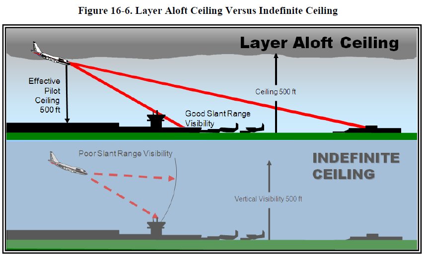
ceilingsgraphicjpg

When we are thinking about flying in IFR weather with low ceilings, there is much to consider.

The FAA goes on to talk more about a low ceiling. “Stratus is the most frequent cloud associated with low ceilings. Stratus clouds, like fog, are composed of extremely small water droplets or ice crystals suspended in air. An observer on a mountain in a stratus layer would call it fog. Stratus and fog frequently exist together. In many cases, there is no real line of distinction between the fog and stratus; rather, one gradually merges into the other. Flight visibility may approach zero in stratus clouds. Stratus over land tends to be lowest during night and early morning, lifting or dissipating due to solar heating by late morning or early afternoon. Low stratus clouds often occur when moist air mixes with a colder air mass, or in any situation where temperature-dewpoint spread is small.”

So next time you are considering flying into low ceilings, think a little more deeply about what the METAR is reporting. Is it a solid overcast? Or should you expect that even when you descend below a layer that you will have difficulty with forward or slant range visibility also that could hinder your ability to complete an approach to a desired destination.